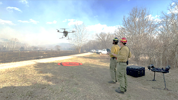
ROLLA–Prescribed burning is a vital tool in forest management, employed by the U.S Forest Service to reduce wildfire risk, enhance ecosystem health, and promote biodiversity. Conducting prescribed burns involves significant resources, many boots on the ground, and careful planning to ensure safety and effectiveness. However, the integration of unmanned aerial systems (UAS) has revolutionized this practice. UAS, commonly referred to as drones, benefit both the Forest Service and the environment it seeks to protect.

On Friday, February 23rd, the Mark Twain National Forest conducted a prescribed burn utilizing UAS, for its first time. Piloted by Tim Donohoe, Greg Reidelbach and Brad Strobelto, the drone successfully completed its mission. There are only a few Forest Service employees qualified to operate the UAS across the nation, so it was exciting to have this highly trained crew on the Forest. Their expertise led to successfully using the UAS to prescribe burn over 200 acres that day.
When hearing of UAS prescribed burning, many people wonder, “how do you light the ground from a flying drone?” First, ping pong sized spheres are placed in a basket below the aircraft. A machine at the bottom of the aircraft than injects the spheres with a substance, that creates an exothermic chemical rection within it. Finally, the drone drops the spheres (sometimes called a dragon egg), and it ignites after hitting the ground below. Before launch, the pilots conducted a bench test to ensure the device is working properly. This test is done prior to flight to ensure the spheres ignition time so they will impact the ground before starting to burn. Upon impact, the sphere produces a slow ignition that expands in its surrounding area. The UAS has one person using the remote controls to steer it through the air and a second pilot that tracks its flight path, monitors battery strength, and observes fire behavior.
For this day’s burn, the aircraft ascended above 500 feet and dispersed a total of 964 spheres, 66ft apart from one another. Additionally, it took four flights to reload spheres to ensure enough aerial ignitions occurred to complete the 200-acre prescribed burn.
UAS play a crucial role in environmental monitoring before, during, and after prescribed burns. They are used to collect data on vegetation density, soil moisture levels, and wildlife habitats. This data facilitates informed decision-making and adaptive management practices. By monitoring ecological responses to prescribed burns, the Forest Service can assess habitat restoration efforts, track invasive species, and evaluate the long-term impact of forest management strategies. The use of UAS on the forest, within the region, and across all federal land management continues to expand.
Tim Donohoe, the UAS assistant module leader, shared, “Each year we are developing new pilots, implementing new technology, and expanding our capacity to meet the needs of the many focus areas that all contribute to the mission of the USDA F.S. and other land management agencies.”
Overall, the use of UAS reduces risk and helps detect potential hazards in many situations when working on public lands. They have emerged as invaluable tools for the U.S Forest Service for conducting prescribed burns effectively, safely, and sustainably. As technology continues to evolve, the integration of UAS will certainly remain at the forefront of innovative approaches to forest management and conservation.
