
LINCOLN, Neb. – Last week featured a highly variable precipitation pattern across the contiguous states. More than three inches of rain fell on broad areas across the central Appalachians, central and southern Virginia, parts of the northern and central Carolinas, much of New England and the adjacent Northeast, parts of Florida, the central Gulf Coast Region, the lower and middle Mississippi Valley, the Upper Midwest, the southern Great Lakes Region, and the central Great Plains. Between five and seven inches soaked some areas in the southern tier of Arkansas, areas near the central Alabama/Mississippi border, the Florida Panhandle, and southwestern Virginia. In contrast, very little precipitation fell from the Rockies westward to the Pacific Coast,, the Dakotas, Oklahoma and western Kansas, most of Texas, central and western Louisiana, part of the Illinois Valley, the Tennessee Valley, the interior Southeast, parts of the upper Ohio Valley, most of the coastal and piedmont areas in the Carolinas, upstate New York, and the central mid-Atlantic Region. In the south-central and southwestern parts of the Lower 48, intense heat accompanied dry weather, with the week averaging 5 to 9 deg. F above normal from Texas westward through the desert Southwest and part of the southern half of the Rockies. Temperatures reached 129 deg. F near Baker, CA on July 16. Elsewhere, the Northeast, Florida, the lower Mississippi Valley, and the West Coast States were also warmer than normal.
Northeast
Heavy rains again soaked much of the Northeast Region last week. Very little dryness remains to the east of a line from the Chesapeake Bay to the east shore of Lake Ontario, with D1 confined to a few spots in south New Jersey and in part of the New York City metro. Heavy rains in the central Appalachians have also nearly eliminated dryness in West Virginia. But large dry areas persist from northern Virginia and Maryland northward through western sections of Pennsylvania and New York, with severe drought (D2) covering central Maryland and adjacent south-central Pennsylvania. According to USDA, 33 percent of pastures in Maine are in poor or very poor condition, as are 16 percent of Pennsylvania’s pastureland.
Southeast
Dryness and drought were already sparse in this Region, and last week’s rains brought additional improvements. Areas from central Virginia southward through most of Florida and westward across Alabama and Georgia are almost free of any abnormal dryness, save for a small part of northeastern North Carolina. Drought is now confined to parts of the northern, western, and southern fringes of the region. Specifically, northern Virginia, northwestern Alabama, and southwestern Florida all have areas of moderate drought, and severe drought (D2) now stretches from the Tampa Bay area southward through Cape Coral. Drought increased to cover slightly larger sections of northern Virginia and southwestern Florida than last week.
South
A broad range of conditions can be found across the region, and even regarding the week’s rainfall totals, some got too much while others languished in heat and drought. Most of Texas was dry this past week, and conditions deteriorated south of the Panhandle. D3 and D4 conditions (extreme to exceptional drought) expanded in the middle of the state, and severe drought (D2) pushed northward toward the central Red River Valley. Agriculture is increasingly impacted by the drought here, with 45 percent of the Texas cotton crop in poor or very poor condition. Almost half of rangelands were in poor or very poor condition, increasingly stressing livestock. In addition, 27 percent of Texas oats are in poor or very poor condition.
Elsewhere, the only other area remaining in D2 to D3 are north-central and southwestern Oklahoma, and agricultural impacts have been far milder outside the Lone Star State. Heavy rains over the past two weeks have left a large swath across the Panhandles, central Oklahoma, the north half of the Lower Mississippi Valley, and much of Tennessee free of any abnormal dryness.
Midwest
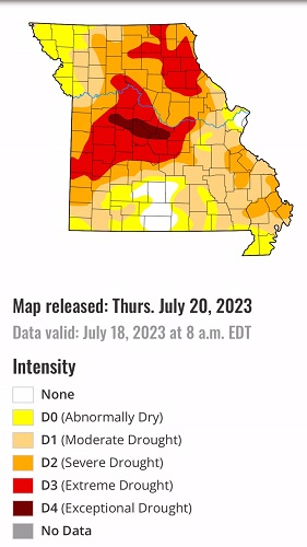
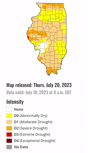
As in areas farther south, the past week was a mixed bag across the Region. Heavy rains improved conditions in significant parts of Michigan, Ohio, and Indiana, with localized improvement noted in parts of Illinois, Missouri, and Wisconsin as well. But in some cases, there was a sharp gradient between areas with copious rainfall and neighboring areas that received little or none, creating a sharp gradient between some areas of severe to exceptional drought, and others only mildly impacted by dryness. Exceptional drought (D4) persisted in central Missouri while D3 covered sizeable sections of central and northeastern Missouri, southeastern Iowa, and both northern and southern parts of Wisconsin. In addition, new areas of extreme drought (D3) were assessed in parts of east-central and southeastern Minnesota. Agricultural impacts have been observed region-wide, particularly in Missouri. Almost three-quarters of pastures and rangelands in the state are in poor or very poor condition, as are one-third of their corn crop and 28 percent of their soybean crop. In addition, 22 percent of both the corn and soybean crops in Illinois are poor or very poor, and 15 to 20 percent of soybeans elsewhere are poor or very poor.
High Plains
Drought remained widespread across Kansas, Nebraska outside the Panhandle, and southeastern South Dakota, with some swaths of improvement incurred in eastern parts of Nebraska and Kansas. Meanwhile, dryness and drought expanded slightly across northern North Dakota, and with the Southwest Monsoon off to a slow start, abnormal dryness has developed over a large part of the southwest quarter of Colorado. Other parts of the central Rockies and most of the Dakotas are unchanged from this past week. In South Dakota, 31 percent of Spring Wheat and 19 percent of oats are in poor or very poor condition, along with 15 percent of Spring Wheat in North Dakota.
West
There was little rainfall in the West Region this past week, but since this is a dry time of year in much of the Region outside the Four Corners States, there was little change in dryness and drought for most areas; however, monsoonal rainfall was again lacking in the Four Corners, prompting a significant expansion of abnormal dryness across New Mexico, Arizona, and southeastern Utah. D0 and D1 also increased across west-central and northeastern Montana.
Caribbean
Moderate to heavy rainfall – between 0.5 and 3.5 inches – fell on most of the Commonwealth of Puerto Rico. The higher amounts fell on areas not currently impacted significantly by dryness, and there were no changes to the areas of D0 to D2 across the Island.
The U.S. Virgin Islands’ drought signal is strongest at 6- to 9-month time periods, with both short- and long-term drought impacts apparent throughout the territory. In many areas, hot weather in late spring and early summer has aggravated short-term drought impacts, especially in the agricultural sector. The Standardized Precipitation Index (SPI) is supportive of severe drought (D2) on St. John and extreme drought (D3) on St. Thomas and St. Croix. From July 11-17, rainfall at the first-order observation sites totaled 0.04 inch at King Airport on St. Thomas and 0.52 inch at Rohlsen Airport on St. Croix. During the drought-monitoring period, volunteer (CoCoRaHS) observers measured rainfall totaling 0.44 inch on St. John; 0.05 to 0.23 inch on St. Thomas; and 0.32 to 0.58 inch on St. Croix. At each the three U.S. Geological Survey wells – one per major island – depth to water has increased to its highest value since autumn 2022, reflective of long-term drought impacts.
Pacific
Precipitation in south-central Alaska ended abnormal dryness around Anchorage, but a few patches in the eastern part of the state remained in abnormal dryness (D0).
It was an unremarkable week across the Hawaiian island chain, and the drought depiction was unchanged. The impacts from Tropical Storm Calvin will be assessed next week, with the Big Island most likely to receive substantial rainfall from the storm.
The Joint Typhoon Warning Center’s Invest 98W moved across the Republic of Palau late in the drought-monitoring period, eradicating abnormal dryness (D0) and delivering heavy showers – locally totaling 10 inches or more – and gusty winds. Abundant moisture associated with the fledgling tropical system (98W) or embedded in the monsoon flow contributed to wet weather in other areas, with 7-day rainfall totals topping 5 inches in the Federated States of Micronesia at locations such as Kosrae and Pohnpei. Wet weather extended as far north as Mili, Republic of the Marshall Islands, where 5.66 inches fell, but the remainder of the RMI experienced mostly dry weather. With short-term dryness continuing across Kwajalein, RMI, D0-S was retained. Kwajalein received exactly one inch of rain during the first 18 days of July. In addition, D0-S was added for Wotje, RMI, where July 1-18 rainfall totaled 1.03 inches. Reservoir storage for Majuro, RMI, decreased slightly, from 29.44 to 27.23 million gallons, between July 1 and 13. Farther west, 7-day rainfall totaled 1 to 2 inches at most locations in the Marianas, with amounts approaching 4 inches on parts of Guam. Elsewhere, dryness was erased across American Samoa, amid the arrival of heavy showers and cooler conditions. American Samoa’s Pago Pago International Airport had reported a daily-record high temperature of 88°F as recently as July 9, but netted 3.44 inches of rain from July 12-17. During the drought-monitoring period, American Samoa’s National Park Service sites at Toa Ridge and Siufaga Ridge received 6 to 9 inches of rain.
Looking Ahead
According to the Weather Prediction Center (WPC), over the next 5 days (July 20 – 24, 2023) moderate to heavy precipitation is expected across parts of the central and southern High Plains from central New Mexico northward into southeast Wyoming, and eastward across western Kansas, the Oklahoma Panhandle, and adjacent locales.
Totals near or over 2 inches are forecast for parts of northeastern Colorado, western Kansas, and the Oklahoma Panhandle. Light to locally moderate amounts are expected in higher elevations of the southern Rockies and some adjacent locations, with at least a few tenths of an inch possible over the central Rockies and part of the Great Basin.
Little or no precipitation is expected elsewhere from the Plains States westward to the Pacific Coast, except in parts of extreme southeastern Texas. Most of the Lone Star State is forecast to receive little if any precipitation. Farther east, moderate to heavy rains are expected near the central Gulf Coast, southeaste4rn Georgia and the eastern Carolinas, eastern Tennessee, and parts of the northern Appalachians.
Anywhere from 1.5 to locally 3.5 inches of precipitation may fall from extreme southeastern Louisiana across southern Alabama and the adjacent Florida Panhandle, The Coastal Plains in Georgia and South Carolina, northeastern North Carolina, and a few areas scattered across northern Pennsylvania, central and northeastern New York, and western New England. Light to moderate totals are expected over most of the middle and lower Mississippi Valley, the mid-Atlantic Region, the Great Lakes Region, and the Ohio Valley, and portions of Peninsular Florida.
Temperatures are expected to remain considerably above normal from the Rockies to the Pacific Coast, over much of the northern and southern Plains, across Peninsular Florida, and in New England. Temperatures should average closer to normal elsewhere, with slightly cooler than normal conditions expected over and near the greater Ohio Valley and the adjacent interior Southeast.
During the ensuing 5 days (July 25 – 29), the Climate Prediction Center (CPC) favors above normal temperatures for almost all of the contiguous states and Alaska, except in the Pacific Northwest. Odds for significantly above-normal temperatures exceed 70 percent in a large area encompassing the eastern Great Basin, central and southern Rockies, and most of the Plains from central North Dakota southward into central Texas. Meanwhile, there are slightly enhanced odds for wetter-than-normal weather over the southeastern Great Lakes Region, the interior Northeast and New England, the western Great Lakes Region and upper Mississippi Valley, and western Washington.
Odds slightly favor drier-than-normal weather in the northern Intermountain West, the Great Basin, much of Oregon and adjacent California, the southern High Plains, most of the central and southern Great Plains, the middle and lower Mississippi Valley, the lower Ohio Valley, the Tennessee Valley, the Southeast, and the South Atlantic Coastal Plain from northern Florida into North Carolina.