
STE. GENEVIEVE – Ste. Genevieve City Administrator reported Saturday on the status of the city.
He said Alliance Water Resources was out cleaning dirt and gravel off the streets Saturday after Friday night’s flash flood. Four inches of rain fell Friday evening in addition to the 1 ½ inches we had from Wednesday & Thursday.
He added that houses along LaHaye Sgtreet were flooded, but no one was hurt.
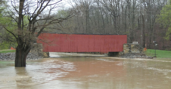
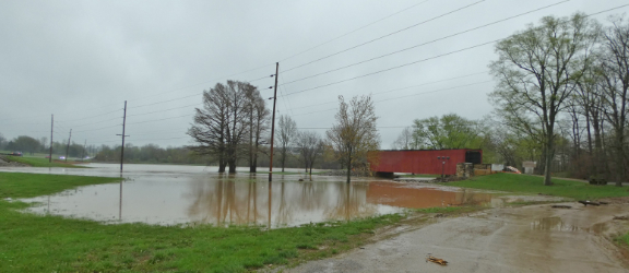
The historic Mary’s River covered bridge which is in the process of being restored following a storm more than a year ago escaped apparent damage from the rising water in the weekend story. (Photos by Richard Janssen)
There were two vehicle rescues by Alliance, the police, and fire department Friday evening. Again, nobody hurt.
Public Works assisted the Levee District to get the debris gates pulled Friday night (at the levee pump station) to allow more water to pass through. No pumps were used.
The National Weather Service reported the following local rainfall amounts:
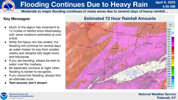
Ste. Genevieve 6.25
Bloomsdale 6.43
Ste. Genevieve 5.17
Chester 2.93
The weather service also reported 29 roads were closed across Perry
County Illinois due to water over them.
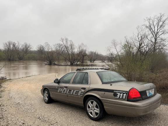
A St Mary police car parked near the old Mississippi River channel at St. Mary.
In Missouri both roads in and out of Piedmont, Mo. were closed due to high water over them. At least
nine or 10 roads in the city had water flowing over them at one point.
At least 15 water rescues had occurred in Van Buren, Mo.
BNSF Railroad reported in a Saturday evening customer advisory the River Subdivision was closed between Ste. Genevieve, Mo., and River Junction, Mo. by high water.
The Missouri Department of Transportation has closed several state routes in Southeast Missouri due to the recent storms.
Road closures in River Region Counties In Missouri;
Perry County:
(These three roads were reported closed, but have since reopened.)
Route M – Route H to County Road 921
Route B – County Road 503 to County Road 502
Route F – County Road 520 to County Road 530
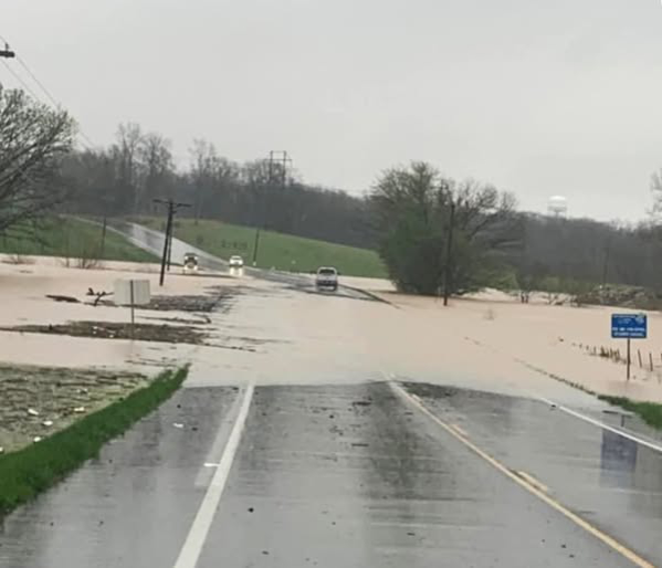
Kiefer Flats is a notorious low section of Highway 32 west of Ste. Genevieve.
Ste. Genevieve
Route 32 – Gisi Road to Siebert Road (Kiefer Flats).
In addition, motorists are encouraged to watch for flash flooding. This could cause water to quickly rise in areas that were previously safe. MoDOT crews will continually monitor state routes, but motorists are also urged to stop and turn around if they discover a roadway has high water.
Routes that were closed in Southeast Missouri include:
Butler County:
Route 158 – 142 to 67 South
Route 142 – Route 158 to Route HH
Route 142 – Route HH to Route EE
Route H – County Road 243 to County Road 231
Route FF – County Road 622 to Route OO
Route W – Route O to County Road 525
Route 142 – County Road 355 to Route B Ripley County
Route 53 – Route HH to the Black River Bridge
Route 53 – Route UU to Route HH down to one lane
Bollinger County:
Route T – Mo 91 to .5 mile south of MO 91
MO 51 – MO 91 to Route H
Cape Girardeau County:
Route 25- Route P to route 77 (Storm Debris)
Route EE- Route 25 to County Road 249 (Storm Debris)
MO 72 at Byrds Creek
Route P – MO 25 to County Road 268
Route Z – MO 25 to Route OO
Route OO – Route Z to Route HH
Route N – MO 25 to County Road 238
Route A- Route U to White Water
Route U – N & T Jct to ½ mile from Black Holer
Route RA – Route U to the end of state maintenance
Route N – Route U to Route NN
Carter County:
Route M- 6miles off Route 60 to the end of Route M
Route 103 – at Big Springs Park
Route Z – entire route
Douglas County:
Route U – 4 miles north of MO 76 at Bryant Creek
Route FF – 2 miles east of MO 14 at Hunter Creek
Route Y – 3 miles west of Route 5 at Cowskin Creek
Route EE – Country Road 160 to County Road 705
Dunklin County:
Route B- Bailey St to County Road 314
Route WW – Route J to MO 53
Route MM – Route J to Route U in Stoddard County
Route DD – Saint Francis River to end of state maintenance
Howell County:
Route 142- Route FF to Route E
Route 63 – Route 14 to County Road 4621
Iron County:
Route F- Route 49 to Route FF in Madison County
Route 40 at Route BB
New Madrid County:
Route 61- Route D to 55
Route H – Route E to County Road 621
Route B – Route 153 to Route 162
Route W – Route E to County Road 621
Route V – Route P to Route 80
Route 61 – Route W to Route HH
Madison County:
Route V- Route F to end of Route V
Route EE at County Road 204
Mississippi County:
Route 62- Route 77 & 62 junction to Bertrand
Route AB- Route N to Route J
Route 80- Route AA to Route B
Oregon County:
Route 160 – Alton to Homas Hill
Route 99 – 1 mile north of Thomasville to Route 160
Roue 19 – At Frederick Creek and Warm Fork Creek
Route 142 – at Eleven Point River
Route A – one-quarter mile west of Route E at Frederick Creek
Route 19 – at Elven Point River
Route BB – County Road 208 to Route C
Ozark County:
Route 95 – Route N to MO 14
Ripley County:
Route A – two miles south of Route 21 to the Arkansas State line
Route 142 – Route B to County Road 355 in Butler County
Route H – Route 142 to AR state line
Route H – Route H and KK intersection
Reynolds County:
MO 106 – 1 mile west of Route F
Route B – County Road 785 to County Road 784
Scott County:
Route Y – Route DD to Route AB
Shannon County:
Route NN- Route H to County Road 522
Route H- County Road 507 to County Road 514
Route YY – County Road 341 to County Road 345
Route N – entire route
Route HH – 3 miles south of MO 106
Stoddard County:
Route O – MO 25 to County Road 337
Route K – Route BB to County Road 248
Route BB – County Road 208 to Route C
Route T – MO 51 to Route J
Route D – Route 25 to Route 153
Route D – County Road 731 to Route 153
Route E – Route N to County Road 542
Route Z- Route VV to County Road 725
Route MM – Route U to Route J in Dunklin County
Ste. Genevieve
Route 32 – Gisi Road to Siebert Road
Texas County:
Route BB – near Decker Road to end of pavement
Route F – Oak Hill to 4th Street
Wayne County:
Route KK – 1 mile from 34 at low water crossing
Route FF – County Road 380 to 2 miles south of County Road 380
Route CC – Route 49 to County Road 348
Wright County:
Route AB- Dennis Road to Hunt Road
Route E- Route 38 to Day Road
Route Z- Jerk Tail to New Home Road
Motorists are encouraged to use extreme caution and plan alternate routes.
“Turn Around – Don’t Drown” as highways become impassable.