
WASHINGTON, D.C. – A low pressure system developed over the Central Plains in conjunction with an amplifying upper-level trough dipping into the northern Plains brought active weather across much of the central to eastern U.S. Warm and moist air from the Gulf of Mexico moved northward ahead of the developing low pressure, producing widespread moderate to heavy rainfall from Texas to Louisiana.
Meanwhile, a cold air mass from Canada dipped into the northern portions of the U.S. bringing blizzard conditions to portions of the Central Plains and Upper Midwest. Temperatures were above-normal across most of the U.S., by as much as 20+ degrees F above average in parts of the Upper Midwest and Northern Plains. The most widespread improvements were made to parts of central Texas, eastern Nebraska, eastern Kansas, southern Louisiana and from northern Alabama to western North Carolina, where above-normal precipitation was observed this past week. Dry conditions continued across the eastern portions of the Southern region, with degradations occurring across much of Mississippi and into Arkansas and Tennessee. Drought and abnormal dryness were also expanded or intensified in portions of the northern Rockies and in parts southern Illinois, southern Texas and in the Southeast. In Hawaii, heavy rainfall improved conditions over parts of Kauai, Oahu and the Big Island, while no changes occurred on Molokai, Lanai or Maui.
Northeast
Light precipitation fell over a large portion of the Northeast this week, while precipitation totals were below-normal across much of the region this week, month-to-date totals were 150% to 400% above normal. Much of the region remains free of drought, while the above-normal precipitation has helped alleviate abnormal dryness in portions of western New York, central Pennsylvania and along parts of the Maryland-Pennsylvania border where improvements were seen in short-term indicators, streamflow and soil moisture levels. For the week, average temperatures were above normal across much of the region with departures ranging from 1 to 9+ degrees F above normal, while pockets of cooler-than-normal temperatures were observed in portions of Delaware and small parts of Maryland and West Virginia. According to the National Weather Service (NWS) National Operational Hydrologic Remote Sensing Center (NOHRSC) regional snow analysis (12/26) reports that the Northeast Region is 9.3% covered by snow with an average snow depth of 0.2 inch and with a maximum depth of 14.4 inches.
Southeast
Precipitation fell across much of the Southeast this week with the heaviest amounts of rainfall being observed in areas from central Alabama to western North Carolina. These areas reported weekly precipitation amounts were up to 600% above normal and ranged between 2 to 8 inches of rainfall. Drought reduction and improvement were based on precipitation amounts, short-term SPI/SPEI, NDMC short-term blends, and improvements to streamflow and soil moisture data. Based on these short-term indicators, extreme drought (D3) was removed from northern Georgia and improved in northeast Alabama where precipitation amounts were up to four inches above normal for the month. Severe drought (D2) and moderate drought (D1) were reduced in parts of Alabama, Georgia, South Carolina and North Carolina, while a small portion of moderate drought in western Virginia was improved this week. Improvements in abnormal dryness (D0) occurred in parts of southern Alabama and along the coast of Georgia and South Carolina. On the dry side, abnormal dryness and moderate to severe drought categories were expanded across parts of Alabama and Georgia, where little precipitation fell. Based on precipitation deficits and short-term indicators, severe drought was expanded in the eastern part of Alabama where precipitation was up to three inches below normal for the month. Moderate drought was expanded in parts of central Alabama and central Georgia, while abnormal dryness was expanded into parts of southern Alabama and central Georgia.
South
Dry conditions continued across the eastern portions of the Southern region this week while heavy precipitation fell across much of Oklahoma and over parts of central and eastern Texas. Large portions of eastern Texas and Oklahoma received between two inches to five inches of rainfall (300% to 600% above normal) this week, resulting in improvement of exceptional drought (D4) in eastern Texas while extreme drought (D3) was removed from northeast Oklahoma and improved in parts of central and eastern Texas. Improvements were also made to moderate drought (D1) to severe drought (D2) conditions, along with abnormal dryness (D0), in this part of the region. Heavy rain was reported (two to four inches of rainfall) over parts of southeastern Louisiana this week, resulting in the 1-category improvement across the area. Conversely, conditions continued to deteriorate in parts of Mississippi, Arkansas and Tennessee, where precipitation totals were two to four inches below normal this month. Exceptional drought was expanded in parts of central and northern Mississippi and was introduced into eastern Arkansas, while extreme drought was expanded into the northern portions of Tennessee and in parts of Mississippi and Arkansas this week. The expansion and intensification of drought categories were based on short-term SPI/SPEI, NDMC’s short-term blend, streamflow and soil moisture data.
Midwest
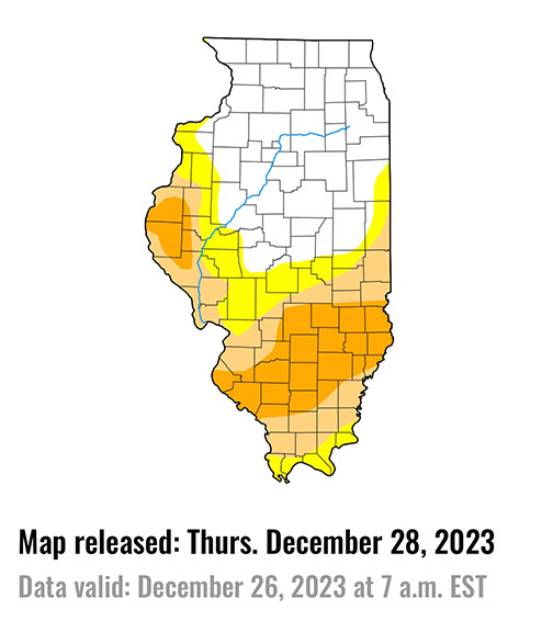
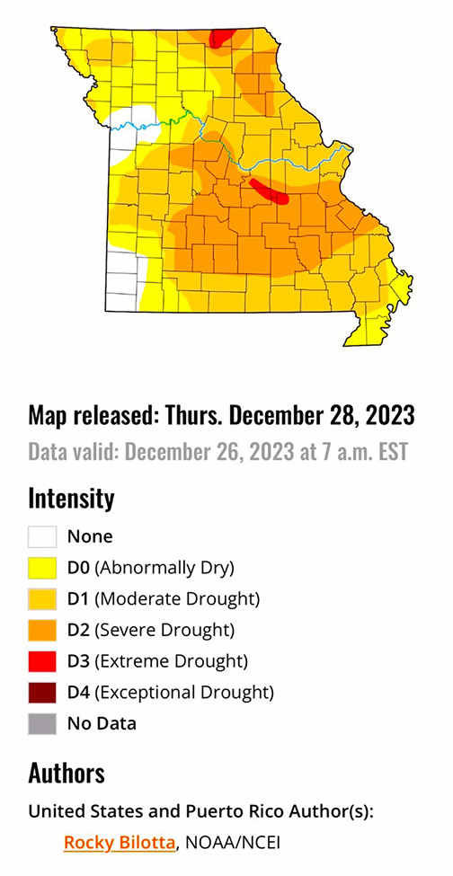
Average temperatures were well above normal across the Midwest, with temperatures ranging between 10 to 25 degrees F above normal this week. Much of the region also observed above-normal precipitation this week, especially along the western portions of the Midwest where the heaviest amounts totaled between two to four inches of rainfall and ranged between one to three inches (300% to 600%) above normal. Above-normal precipitation helped to alleviate longer-term precipitation deficits and improved soil moisture and streamflow impacts, resulting in improvements to abnormal dryness (D0) and all drought categories. A broad 1-category improvement was made across western Missouri, while additional improvements were made in parts of western Minnesota, northwest Iowa and western Illinois. Meanwhile, dry conditions continued to affect southern parts of Illinois this week, where precipitation is as low as 25% of normal for the month. Degradations were supported by precipitation deficits, short-term SPI/SPEI timescales, streamflow, soil moisture and groundwater data. The water table levels in Carbondale (Jackson County, IL) and near Rend Lake (Jefferson County, IL) are below normal, with both at or near record-low levels. Based on these short-term indicators, Moderate drought (D1) to severe drought (D2) was expanded in southern Illinois.
High Plains
Heavy precipitation fell over much of eastern portions of the region, where rainfall totals were greater than 600% of normal and ranged between 1 to 4 inches this week. Exceptional drought (D4) was improved in eastern Nebraska, while extreme drought (D3) was improved in eastern portions of Nebraska and Kansas where precipitation totals were up to 3 inches above normal for the week. Above-normal precipitation also led to improvements to severe drought (D2) and moderate drought (D1) over parts of eastern Kansas and northeast Nebraska. Abnormal dryness (D0) was improved along parts of the eastern border of the High Plains and in portions of western Kansas and eastern Colorado. Conversely, dry conditions persisted in portions of eastern Colorado and Wyoming where precipitation remains below normal this week. Deteriorating conditions shown in short-term SPI/SPEI, streamflow, soil moisture and snow water equivalent (SWE) data justified degradations across these states. Abnormal dryness was expanded in parts of northern Colorado and in eastern and southern Wyoming, while abnormal dryness was introduced in north-central and northeast Wyoming.
West
Much of the West remained as status quo this week. Precipitation fell across much of the region, which was enough to prevent further degradation but not enough to warrant large improvements. Heavier precipitation fell across the southern portions of Arizona and New Mexico, where rain totals were greater than 600% above normal this week. These beneficial rains, along with precipitation percentiles and short-term SPI/SPEI, soil moisture and streamflow data, resulted in abnormal dryness (D0) and moderate (D1) to extreme (D3) drought improvements along the southern border. Portions of La Paz and Yuma counties reported weekly rainfall totals up to 6 inches above normal. Conditions remained dry in northern parts of the Rockies, resulting in further deterioration across western Montana and eastern Idaho. Moderate drought and abnormal dryness were expanded in these areas based on short-term SPI/SPEI data, low snow water equivalent (SWE) percentiles and precipitation and soil moisture deficits. As for temperature this week, much of the region was above normal with well-above-normal temperatures were observed in parts of northeast Montana which were greater than 10 degrees F above normal.
Caribbean
Heavier rain fell across much of the northern half of Puerto Rico, but no improvements were made based on long-term precipitation deficits. Conditions continued to deteriorate along the southern half of the island, resulting in the slight expansion of abnormal dryness (D0) in southwest Puerto Rico.
The remnants of a cold front combined with other weather features to trigger scattered showers across the U.S. Virgin Islands (USVI) during this U.S. Drought Monitor (USDM) week (December 20-26). But precipitation amounts were low, due in part to a patch of dry air and Saharan dust that briefly filtered across the islands. Based on data available at the time of this report, weekly rainfall totals ranged from a tenth to a half inch on St. Thomas and from a tenth to three-fourths of an inch on St. Croix, with only a few hundredths of an inch reported on St. John. Weekly rainfall totals at the airport stations on St. Croix and St. Thomas were well below normal.
According to USGS well observations, the groundwater level on all 3 islands showed little change from last week – some up and down movement, with depth to water ending up a little deeper than last week. Depth to water on December 25: 5.57 feet on St. John, 7.35 feet on St. Thomas, and 33.16 feet on St. Croix. Satellite VHI showed a few areas of vegetative stress.
With December and year-to-date precipitation totals still well below normal, short- and long-term moderate drought (D1-SL) continued on St. Croix. December has been wet but long-term precipitation deficits remained, so long-term severe drought (D2-L) continued on St. Thomas, while St. John continued with a D-Nothing status (no drought or abnormal dryness).
Pacific
Below-normal precipitation was observed across much of Alaska this week, while precipitation was above normal in south-central Alaska and parts of the interior and Panhandle. Alaska remained free of drought and abnormal dryness this week.
Precipitation varied across the islands of Hawaii this week. Heavier precipitation fell on Kauai, Oahu and the Big Island, resulting in the improvements of drought and abnormal dryness on these islands, while no changes were made on Molokai, Lanai or Maui this week.
The weather conditions across the U.S.-Affiliated Pacific Islands (USAPI) during this U.S. Drought Monitor (USDM) week (December 20-26) consisted of heavy rains associated with a near-equatorial trough (NET) south of the main islands of Micronesia that extended south of the equator as the South Pacific Convergence Zone (SPCZ), and a dry trade-wind pattern north of the NET that dominated most of Micronesia. Some disturbances (troughs or a wind surge) moving in the trade-wind flow brought showers to some areas, but dry weather dominated and began drying out vegetation, especially in the Marianas, increasing fire danger. The SPCZ continued a wet pattern across the Samoan Islands. Based on data available at the time of this report, weekly rainfall totals were about an inch in the Marianas but ranged from no rain to a half inch at most other stations in Micronesia. More than 8 inches of rain was recorded in American Samoa.
Yap reported 1.17 inches of rain this week and 2.84 inches so far in December. These values are far less than the 2-inch weekly minimum and 8-inch monthly minimum needed to meet most water needs. This week marked the fifth consecutive dry week. If no more rain falls this month, December 2023 will rank as the third driest December in a 73-year record, November-December 2023 will rank as the fifth driest November-December, and October-December as the seventh driest. As a result, moderate drought (D1-S) developed at Yap.
Only 0.79 inch of rain was reported at Ulithi this week, with 2.63 inches for December to date. This week marked the eighth consecutive dry week. If no more rain falls this month, December 2023 will rank as the fifth driest December in 41 years, November-December third driest in 40 years, and October-December tenth driest. Moderate drought was worsened to severe drought (D2-S) at Ulithi.
Moderate drought (D1-S) continued at Wotje, which had 0.22 inch of rain this week and 1.94 inches for December. Abnormal dryness (D0-S) continued at Ailinglaplap where only 1.17 inches of rain was reported this week and 5.46 inches for December. Lack of data prevented an analysis from being made at Fananu and Utirik. It was a wet week at Tutuila and most of the stations in the Marianas, so D-Nothing (no drought or abnormal dryness) continued there. For the rest of the stations, this week was dry but previous weeks and/or December have been wet, so D-Nothing continued.
Looking Ahead
During the next five days (December 26-30, 2023), An initial Plains/Midwest upper low will work to establish the eastern upper trough, and an associated surface system will spread rainfall of varying intensity over the East early-mid week along with the potential for lingering snow over the north-central Plains. Over the West, most precipitation should focus near the West Coast with a couple frontal systems tending to produce the highest totals over/near northern California. In terms of temperatures, expect unseasonably warm conditions in the East Tuesday and Wednesday ahead of the approaching frontal system. Morning lows should be particularly anomalous with readings 20-30 degrees above normal for much of the East and Upper Midwest. Warmer than normal temperatures will likely linger even longer in the Northeast through Thursday or Friday. Cooler air behind the system will initially still be on the mild side, with only slightly below normal readings over the central-southern Rockies/Plains on Tuesday. As upper troughing becomes established over the East later in the week, the Southeast and vicinity should trend cooler with temperatures dropping to 5-10 degrees or so below normal. Much of the West should see moderately above normal temperatures through the period.
The Climate Prediction Center’s 6-10 day outlook (valid December 31, 2023 – January 4, 2024) favors above-normal precipitation from California to Alabama, and across much of Alaska, with below-normal precipitation most likely from the northern Plains to the Northeast, in portions of the Northwest and Hawaii, and in parts of southern Florida and Alaska Panhandle. Increased probabilities for below-normal temperatures are forecast for much of southeastern U.S. and on the eastern islands of Hawaii, while above-normal temperatures over much of the West, along the northern tier and in parts of the southern Plains, as well as Alaska and western islands of Hawaii.
Author(s):
Rocky Bilotta, NOAA/NCEI
Richard Heim, NOAA/NCEI