
National Drought Mitigation Center
LINCOLN, Neb. – Areas of the High Plains, Central Plains, Midwest and South had the most active precipitation patterns over the last week. Record-setting rains were recorded over western Kentucky and the area had significant flooding. The monsoon season in the Southwest has remained quiet with record-setting heat dominating the region into the southern Plains. Temperatures were cooler than normal over most of the central Plains, Midwest and Mid-Atlantic with departures of 2-4 degrees below normal widespread. Temperatures in the West, Southwest, South and Southeast were warner than normal, with some departures in Arizona 8-10 degrees above normal for the week and most other areas at least 2-4 degrees above normal.
Northeast
Temperatures in the region were mainly cooler than normal outside of New England, which had temperatures that were near normal to 2-4 degrees above normal in Maine. Precipitation was spotty and there were equal numbers of dry and wet areas. The most abundant rains were observed over Pennsylvania into the DelMarVa Peninsula as well as eastern New York and portions of Vermont and Connecticut. The cooler and wetter pattern allowed for some improvements in the region this week. Abnormally dry conditions were improved over both western and eastern New York, southern New Jersey, central and western Pennsylvania, northern Maryland and southern Connecticut. Moderate drought conditions were improved over western New York and western Pennsylvania as well as northern New Jersey.
Southeast
Temperatures in the northern portion of the region were cooler than normal with departures of 1-2 degrees below normal. Farther south, temperatures were above normal, although Florida saw departures of 2-3 degrees below normal. Precipitation was greatest over northern Alabama, northern and southern Georgia, north Florida and northern South Carolina. The driest conditions were observed over southern Alabama into the Florida panhandle as well as in central Georgia. With much of the region not being impacted by dryness or drought, changes were limited. With some areas dry over the last several weeks, conditions are favorable for rapidly changing status if the pattern persists. Abnormally dry conditions were improved in northeast North Carolina and two new pockets of abnormally dry conditions were added in southern North Carolina and northwest South Carolina. A new area of extreme drought was added along the western coast of Florida where the rainy season has yet to occur and record-setting dryness is impacting the region.
South
Temperatures were cooler than normal throughout Oklahoma and most of Arkansas, but warmer than normal elsewhere with departures in west Texas 6-8 degrees above normal. Areas of northern Oklahoma and Arkansas recorded above-normal precipitation, but most other areas were dry with little to no rain this week. A new area of severe drought was added over east Texas into southern Louisiana. Moderate drought was expanded over east Texas and abnormally dry and moderate drought conditions expanded over south Texas with a new area of severe drought introduced. Severe and extreme drought expanded over central and eastern portions of Texas as well. Southern Mississippi had abnormally dry conditions expand this week related to short-term dryness.
Midwest
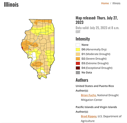
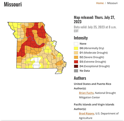
Almost the entire region was cooler than normal for the week with departures of 2-4 degrees widespread. Conditions were mainly drier than normal throughout the region with the driest conditions over Minnesota, Iowa, southern Wisconsin, northern and central Illinois, Indiana and southern Michigan. Central Missouri, southern Illinois and western Kentucky were the wettest areas, with some of these areas having well over 200% of normal precipitation for the week. Changes were mixed with improvements in the south for those areas that had the best rains and degradations farther north. Minnesota had moderate drought expand in the northwest with severe and extreme drought expanding in the central and southern portions of the state. Wisconsin saw severe drought expand in the northwest and west central with some expansion of extreme drought in the south. Moderate drought was expanded over northern Iowa and northern Illinois with abnormally dry and moderate drought expanding over western and central Illinois. Southern Illinois was the recipient of some of the extreme rainfall and some areas saw two-category improvements this week. That same extreme rainfall allowed for two-category improvements over western Kentucky, and portions of northern Kentucky had abnormally dry conditions eliminated. A new area of moderate drought was added over eastern Kentucky. Improvements to abnormally dry conditions occurred over northern and southern Ohio and northwest Ohio into Indiana. Indiana had some expansion of moderate drought in the northern portion of the state. Missouri had a mix of improvements and degradation as the northern and southern regions saw drought expansion and intensification while the central and southeastern portions had widespread improvement. Exceptional drought was removed from Missouri this week.
High Plains
It was a mostly dry week across the region with the most significant rains falling over eastern Wyoming, western Nebraska, eastern Colorado and western Kansas, with some pockets of above-normal precipitation over southern South Dakota and eastern Nebraska as well. Temperatures were cooler than normal over much of the region with departures of 1-3 degrees below normal. Abnormally dry and moderate drought conditions were expanded in northern North Dakota and all of western Kansas saw a full categorical improvement this week. Improvements to severe and extreme drought were made over southeast South Dakota and into northern Nebraska. Severe drought was expanded in eastern South Dakota along the border with Minnesota.
West
The ongoing heatwave was impacting much of the Southwest into southern California over the last several weeks. Temperatures in the region were well above normal for most areas and some departures in the Southwest were 8-10 degrees above normal this week. Areas of northern Utah and Nevada as well as portions of western Wyoming had above-normal rainfall this week. Moderate and severe drought were expanded in Idaho as well as the north and western portions of Montana. Abnormally dry conditions expanded over southern and southwest Colorado with moderate drought introduced this week in south central Colorado. A vast expansion of abnormally dry conditions was made in Arizona into western New Mexico, with moderate and severe drought expanding over southern New Mexico. Moderate drought also expanded over northern and northwest New Mexico.
Caribbean
Severe drought was added to northwest Puerto Rico where lingering dryness continues.
The U.S. Virgin Islands continued to experience both long- and short-term drought, with adverse impacts on surface and groundwater reserves, as well as agriculture. The drought-monitoring period, ending the morning of July 25, featured hot weather and minimal rainfall, resulting in no changes to the drought depiction. Based on supporting evidence from Standardized Precipitation Index (SPI) values at time scales ranging from 1 to 9 months, St. John remained in severe drought (D2), while St. Thomas and St. Croix remained in extreme drought (D3). From July 18-24, rainfall at the first-order observation sites totaled 0.13 inch at King Airport on St. Thomas and 0.34 inch at Rohlsen Airport on St. Croix. During the drought-monitoring period, volunteer (CoCoRaHS) observers measured rainfall ranging from 0.00 to 0.12 inch. The U.S. Geological Survey’s Adventure 28 Well on St. Croix had a depth to water approaching 33 feet by July 25, a sharp increase from near 25 feet in November 2022. Similarly, depth to water at the Grade School 3 Well on St. Thomas topped 16 feet on July 25, an increase from less than 1.5 feet in early-November 2022.
Pacific
In Alaska, abnormally dry conditions expanded with some slight improvements also made to previously dry areas.
In Hawaii, Tropical Storm Calvin made a close pass to the Hawaiian Islands last week. The rainfall mainly occurred on the windward and southeast flank of the Big Island and the windward slopes of Maui. Improvements were made to moderate drought and abnormally dry conditions on Maui and the Big Island in response to the recent rains.
The Joint Typhoon Warning Center’s Invest 98W (later Typhoon Doksuri) moved away from western Micronesia and the Republic of Palau early in the drought-monitoring period, but was trailed by Invest 91W, taking a similar path. The new system (91W) also helped to enhance a Micronesian monsoon surge, maintaining generally wet conditions—with widespread weekly rainfall totals of 4 to 10 inches—extending across the Federated States of Micronesia and into the Republic of Palau.
Meanwhile, mostly dry weather returned across American Samoa, following the previous week’s significant rainfall. Through July 25, month-to-date rainfall at Pago Pago International Airport totaled 4.44 inches, with most of that precipitation (3.68 inches) falling from July 12-18. Much higher totals, ranging from 6 to 9 inches, had been observed during the mid-July wet spell at American Samoa’s National Park Service sites (Toa Ridge and Siufaga Ridge).
In the Marianas, automated observing equipment on Saipan has recorded less than an inch of rain during 7 of the last 8 weeks, with month-to-date precipitation through July 25 totaling 3.11 inches (55 percent of normal). Other observation sites on Saipan have also received little rain in recent weeks, resulting in the introduction of abnormal, short-term dryness (D0-S). Elsewhere, abnormal dryness (D0-S) persisted in northern sections of the Republic of the Marshall Islands, across Wotje and Kwajalein, despite a slight increase in shower activity. Wotje’s weekly (July 19-25) total of 2.03 inches followed 4 weeks in a row with rainfall ranging from 0.00 to 1.72 inches, while Kwajalein’s sum of 1.61 inches followed 4 consecutive weeks with rainfall totaling less than 0.60 inch.
Looking Ahead
Over the next 5-7 days, much of the West and the southern Plains into the South look to be quite dry. Some monsoonal moisture is anticipated over the Four Corners with light precipitation anticipated over the High Plains and Midwest. The wettest conditions are anticipated over the Great Lakes and into the Northeast as well as the Florida peninsula. Temperatures are anticipated to be above normal over the central and southern Plains and into the South. Cooler-than-normal temperatures are anticipated over the coastal areas of the West.
The 6–10 day outlooks show that there are above-normal chances of warmer-than-normal temperatures over the lower Mississippi Valley and most of the southern Plains into the Southeast as well as in the Pacific Northwest. There are also above-normal chances of cooler-than-normal temperatures over New England. The greatest likelihood of above-normal precipitation is over the Rocky Mountains and New England while the greatest likelihood of below-normal precipitation is in the Southeast.
Author(s):
Brian Fuchs, National Drought Mitigation Center
Brad Rippey, U.S. Department of Agriculture
Dryness Categories
D0 Abnormally Dry—used for areas showing dryness but not yet in drought, or for areas recovering from drought.
Drought Intensity Categories
D1 Moderate Drought
D2 Severe Drought
D3 Extreme Drought
D4 Exceptional Drought
Drought or Dryness Types
S Short-term, typically less than 6 months (agriculture, grasslands)
L Long-term, typically more than 6 months (hydrology, ecology)
SL Area contains both short- and long-term impacts