
National Drought Mitigation Center
Heavy to excessive rainfall significantly improved or removed drought from parts of the Northeast and south-central Great Plains. The heaviest amounts fell in a broken pattern from lower New York through Vermont, and in a swath from central Oklahoma through the fringes of the Texas and Oklahoma Panhandles. Many of these areas recorded over 6 inches of rain, with totals approaching 9 inches in a few isolated spots. Lesser but still heavy amounts exceeding 3 inches fell on portions of the central Plains, Texas Gulf Coast, lower Mississippi Valley, interior Southeast, Carolina Coastline, and upper Great Lakes Region, allowing drought to ease in some of these areas. In contrast, other parts of Texas, the middle and upper Mississippi Valley, the lower Great Lakes, and the central and northern Dakotas received only several tenths of an inch of precipitation at best, resulting in several areas of deepening drought. Hot weather from the desert Southwest through the southern Plains and across Florida exacerbated drought conditions there. West of the Rockies, seasonably dry conditions prevailed.
Northeast
The recent dryness in much of the Northeast Region was abruptly ended by heavy to excessive rainfall last week. Rainfall totals of 3.5 to locally 8.0 inches of rain pelted much of eastern Pennsylvania and the west half of New England, with numerous reports of flash flooding. Maine, lower New England, eastern New York, much of New Jersey, and a few patches across the mid-Atlantic Region and West Virginia recorded moderate to heavy amounts with isolated totals exceeding 3 inches. A few tenths of an inch of precipitation fell elsewhere, at best. Broad drought improvement or removal resulted across much of New England and the adjacent Northeast, but conditions were generally unchanged in the relatively drier areas, including parts of the mid-Atlantic Region and western sections of Pennsylvania and New York. The worst conditions on the Drought Monitor (D2) are now restricted to central Maryland and adjacent Pennsylvania
Southeast
Dryness and drought were already sparse in this Region, and last week’s rains brought additional improvements to a few areas in Virginia, the Carolinas, Georgia, and Alabama. Conditions along the western Florida coastline, however, intensified this past week amid subnormal rainfall and periods of near-record heat. A new area of D2 was introduced along the western Florida coast from the Tampa Bay area southward into Cape Coral while D0 and D1 conditions expanded eastward toward the middle of the Florida Peninsula. Parts of the western Florida Peninsula have recorded 2 to 5 inches less than normal rainfall for the past 30 days, with the largest departures observed just south of the Tampa Bay area.
South
Highly variable condition were noted across this region. Heavy to excessive rainfall triggered some flooding in an area from the Texas and Oklahoma Panhandles southeastward through northeastern Texas, with several locations in central Oklahoma reporting 7 to locally near 10 inches of rainfall. Existing dryness in this area was eliminated or at least greatly improved. Meanwhile, most of interior and western Texas saw little if any rainfall, prompting expansion and intensification of dryness and drought there. In addition, much of northern Arkansas and adjacent Oklahoma reported only light rainfall at best, allowing expansion and intensification of D0 to D2 conditions across this area Other parts of the South were covered by a broken pattern of moderate to heavy rainfall, with a few locales reporting over 3 inches of rain. Scattered areas of improvement were noted through these regions.
Midwest
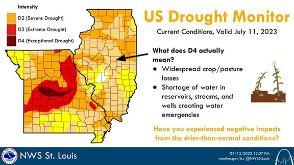
As in some other parts of the country, rainfall totals were a mixed bag across the Midwest Region last week, though more deterioration was noted than improvement. Most of Missouri, Iowa, Minnesota, Wisconsin, and the lower Great Lakes Region recorded subnormal rainfall, persisting or worsening dryness in these regions. A new area of exceptional drought (D4, the most intense category) was introduced in parts of central Missouri while D3 covered a large part of central and northeastern Missouri, southeastern Iowa, and southwestern Wisconsin. Precipitation deficits of 7 to 12 inches accumulated during the last 90 days in a large portion of central and northeastern Missouri, and 4- to 8-inch deficits were common in southwestern Wisconsin, parts of eastern Iowa, and scattered patches across Indiana, Illinois, the lower Peninsula of Michigan, and isolated spots in western Ohio. On the other hand, moderate to heavy rainfall doused the northern Great Lakes Region, the Upper Peninsula of Michigan, and a few locales in eastern sections of the region, leading to some improvement there.
High Plains
Heavy rainfall soaked much of south-central and southwestern Kansas, with 4 to locally 8 inches observed in many areas. Significant drought reduction resulted, although some degree of longer-term dryness remained in most locations. Eastern Nebraska, southeastern South Dakota, eastern Colorado, and a few other parts of Kansas received moderate to locally heavy rains, prompting substantial if less-widespread improvement in those areas. In addition, parts of Wyoming continued to benefit from the exceptionally wet and (in higher elevations) snowy winter, so D0 and D1 areas were again whittled down slightly. In contrast, moderate drought (D1) expanded in both the northwestern and northeastern sections of North Dakota, where persistently below-normal precipitation has been observed for the past few months. Although more improvement than deterioration occurred last week, exceptional drought (D4) remained over parts of southeastern Kansas, portions of west-central and north-central Kansas, and a few patches in eastern Nebraska.
West
Scattered light to moderate precipitation fell on parts of the southern half of Montana, eastern New Mexico, and isolated sites in the northern Intermountain West. Highly isolated amounts of no more than 0.2 inch were observed elsewhere, with most locations reporting no measurable precipitation. Growing moisture deficits led to areas of drought expansion and intensification across Washington and Oregon, a portion of northernmost Idaho, and parts of northern Montana. Farther south, despite the dry week, the exceptionally wet and snowy winter continued to benefit much of Utah, the Great Basin, and the desert Southwest. D2 was removed from southern Nevada, and areas of D0 and D1 were reduced in size. In the West Region, there is no longer any D2 to the south and east of central Oregon.
Caribbean
Moderate to heavy rainfall in eastern sections of the Commonwealth brought an end to abnormal dryness (D1) there, and moderate rainfall over northeastern parts of the Island prompted the removal of severe drought there, leaving the Island free of any D2 or worse designations. But moderate drought (D1) continued over some northwestern parts of the Island, and abnormal dryness still covered much of the northern tier, and a couple of patches farther south over south-central and southwestern sections.
Precipitation for the U.S. Virgin Islands was largely above normal for St. Thomas and St. Croix this week, per CoCoRaHS reports, ranging from 0.63 to 1.7 inches for St. Thomas and 0.48 to 0.95 for St. Croix. St. John received 0.37 inches, which is below normal.
The ample precipitation that fell at the end of June on St. John and St. Croix continued to be reflected in the Standardized Precipitation Index (SPI) for those islands, which were each improved last week. No changes were made to the drought depictions for the islands from last week, leaving St. John at D1-S and St. Croix at D3-SL. The SPI for St. Croix did indicate the possibility of easing drought conditions, but the abundant rainfall exceeding 3 inches at the end of June fell quickly, may not have been well absorbed by the soil and only minimally improved the well level, so St. Croix was kept at D3-SL. St. Thomas remained at D2-SL as the SPI indicated was appropriate.
Pacific
Scattered rainfall in Yukon Flats removed the small moderate drought (D1) area in that region, although much of the region remained under D0 (abnormal dryness). Farther south, below-normal shower and thunderstorm activity has resulted in 30- to 45-day rainfall deficits in the Delta Junction and Glennallen areas, where two new areas of D0 were introduced. Meanwhile, moderate rains fell on parts of the Anchorage area, although the Palmer area was drier. As a result, the south side of the southern Alaska D0 was removed.
In Hawaii, persistently weaker-than-normal trade winds continued to prompt expansion and intensification of dryness and drought across the Islands. Most notably, severe drought (D2) developed along the south-central and southwestern coastline of Maui, and moderate drought (D1) expanded across coastal southwestern Molokai, and remained unchanged over much of central and western Maui, as well as near the northeastern coast of the Big Island.
The Republic of Palau received ample rain with 4.76 inches at Palau IAP and 5.21 inches at Koror COOP. Water supplies should be brimming.
The Mariana Islands all had enough rain to be free of drought. Guam received 2.20 inches, while Rota reported 2.54 inches. Saipan received from 0.97 inches at Saipan IAP. These islands need an inch weekly to meet minimum water needs.
The Federal States of Micronesia were mixed with about half of locations receiving two inches or more, while other locations reported less than 2 inches. All locations received enough rainfall in recent weeks to have enough water. Kapingamarangi received 13.21 inches. No dryness or drought for any of the FSM.
The Marshall Islands all reported less than 2 inches of precipitation for the week, but most received enough rain recently that water supplies should be adequate. Only Mili received more than an inch of rain for the week. Rainfall was scarce for Kwajalein for a third consecutive week, so abnormal dryness (D0) was introduced.
American Samoa received little rain in the past three weeks so abnormal dryness was introduced for Pago Pago, which collected 0.30 inches of rain this week.
Looking Ahead
According to the Weather Prediction Center (WPC), over the next 5 days (July 13 – 17) heavy precipitation is expected across Missouri and adjacent areas, where some of the most acute rainfall deficits have been observed recently. Amounts of 1.5 to locally over 3.0 inches are expected. Similarly heavy rains are anticipated in the eastern Lower Mississippi Valley, the central Appalachians, the southeastern Great Lakes Region, much of New England and the adjacent Northeast, parts of the mid-Atlantic Region, and southern Florida. Additional flooding is possible in portions of New England. Light to locally moderate rain is anticipated in most other locations east of the Mississippi River and across the central and south-central Great Plains. In contrast, most of Texas should see little if any precipitation, and seasonable dryness is expected west of the Rockies. Hot weather is anticipated along the southern tier of the country from the desert Southwest eastward through much of Florida, especially later in the period.
During the ensuing 5 days (July 18 – 22), the Climate Prediction Center (CPC) favors above normal temperatures across most of the contiguous 48 states, with odds leaning toward near or slightly below normal temperatures only in most of Washington, and in a swath from the northern Plain eastward across the upper Midwest and northern Appalachians through the lower Northeast. Dry weather is favored to continue across Texas and in most of the Intermountain West and Northwest. Increasing monsoonal activity is expected in southern Arizona and adjacent areas, where odds slightly favor above-normal precipitation. A slight tilt of the odds toward wetter than normal weather also covers the central and northern Plains, the Northeast and adjacent mid-Atlantic Region, and southern Florida.
Author(s):
Richard Tinker, NOAA/NWS/NCEP/CPC
Denise Gutzmer, National Drought Mitigation Center
Dryness Categories
D0 Abnormally Dry—used for areas showing dryness but not yet in drought, or for areas recovering from drought.
Drought Intensity Categories
D1 Moderate Drought
D2 Severe Drought
D3 Extreme Drought
D4 Exceptional Drought
Drought or Dryness Types
S Short-term, typically less than 6 months (agriculture, grasslands)
L Long-term, typically more than 6 months (hydrology, ecology)
SL Area contains both short- and long-term impacts