
By National Drought Mitigation Center
ST. LOUIS – The National Drought Mitigation Center on Thursday, July 6, 2023 released its latest National Drought Summary.
Heavy rains fell this week across parts of the Midwest, Ohio River Valley and Northeast, which led to widespread improvements from southeast Nebraska to central Illinois, southern Indiana, and central and eastern Kentucky. To the south and west, in southern Missouri, the Texas-Louisiana border and other parts of central Texas, drier weather led to worsening precipitation deficits, and significant problems with hay production in parts of southern Missouri. Dry weather in the Upper Midwest led to further degrading conditions in parts of Michigan, Wisconsin and Minnesota. A re-evaluation of conditions in parts of the western Great Plains led to some improvements to long-term dryness and long-term moderate drought in the Texas and Oklahoma Panhandle region, and in western Nebraska and eastern Wyoming, respectively. A mix of degradations and improvements occurred in the Pacific Northwest. No changes were made to the USDM depictions this week outside of the Lower 48.
Northeast
Heavy rains fell in parts of the Northeast this week, bringing continued relief to areas of drought and abnormal dryness (particularly along the Atlantic coast from Philadelphia up through New York and through Vermont, New Hampshire and Maine) and improving streamflows and alleviating some of the short-term precipitation deficits. The North Atlantic coast saw abnormal dryness completely removed from Maine, New Hampshire, Rhode Island and Massachusetts, except for the Cape Cod area, which still remains in abnormally dry condition. Conditions also improved in parts of New York, Pennsylvania, New Jersey, Delaware and West Virginia due to scattered heavy rains in the last week. Severe drought in central Maryland and southeast Pennsylvania remains from last week.
Southeast
This week, heavy rainfall was spotty across the region with pockets in south Florida and near the northern Alabama-Georgia border allowing for improvements to be made. Northern Virginal also saw improvements in moderate drought and abnormal dryness based on recent rainfall and increased streamflow. Temperatures in most of the Southeast were near normal to a few degrees above and below normal. Moving south from Virginia there is a steady gradient from cooler-than-normal temperatures to warmer-than-normal temperatures. While south Florida saw areas of heavy precipitation, the western Peninsula saw abnormal dryness and moderate drought introduced from the Tampa Bay area south to Fort Myers in part because of continued low streamflows and soil moisture deficits.
South
Much warmer-than-normal temperatures covered the South as it is enveloped in the continuing heat wave, especially eastern Texas and Louisiana where temperatures ranged from 4 to 8 degrees above normal compared to the rest of the region where temperatures were near normal to 4 degrees above normal. There was expansion of abnormal dryness and moderate drought along the western Gulf Coast where temperatures soared and little to no precipitation fell, providing no relief to the low streamflows and dry soil conditions. Tennessee did see the removal of moderate drought conditions along the Tennessee-Kentucky border after heavy rainfall. Conditions were status quo for the rest of the region despite seeing warmer-than-normal temperatures and slightly below-normal precipitation this last week.
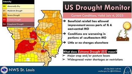
Here are the latest conditions from the US Drought Monitor. The main highlights are improvement across parts of Illinois and east-central Missouri and worsening conditions in portions of southeastern Missouri. Several areas are in Extreme Drought (D3), which includes major crop and/or pasture losses and widespread water shortages.
Midwest
This week’s weather in the Midwest region varied substantially, with heavy rain falling from St. Louis across much of central and northern Illinois, Kentucky, and parts of Indiana and Ohio to continued dry conditions in southern Missouri, eastern Wisconsin, and central and northwest Minnesota. Widespread changes occurred, as precipitation deficits grew and streamflow and soil moisture issues continued in locations that missed out on the rain, while drought and abnormal dryness improved to varying degrees in areas that saw more rain. In southwestern portions of Missouri, major agricultural damage continued to occur as significant spring dryness has continued into the summer, and drought expanded and worsened. Localized worsening of conditions happened in parts of Iowa, which missed out on heavier rainfall. Extreme drought developed in and around Madison, Wisconsin, and severe drought expanded eastward to Milwaukee. Large-scale improvements occurred in parts of southern Iowa, northern Missouri, central Illinois, Chicago, southern Indiana, and central and eastern Kentucky, as well as parts of Ohio, where rainfall was sufficient to put a significant dent in precipitation deficits, increase streamflow, and improve soil moisture.
High Plains
This week saw widespread improvements across the Great Plains. Much of the Great Plains portion of the region, with the exception of eastern Kansas, northern North Dakota and western Colorado, saw widespread precipitation, some of it heavy. Much of southeast and northwest Nebraska, northeast South Dakota and along the Wyoming-South Dakota border saw rainfall of at least 2 inches over the last week. In western Nebraska, eastern Wyoming and the Dakotas, this led to widespread improvements to the drought depiction in areas where the heaviest rains fell. Nebraska saw the most improvements in the High Plains with continued improvement in the Panhandle, the Sandhills up to the South Dakota border and the southeast near Nebraska City. Meanwhile, conditions continued to worsen in a majority of Kansas, particularly in the east and southeast where mostly dry weather continued. Given continued decreases in soil moisture and groundwater, and growing short- and long-term precipitation deficits, degradations were made from Manhattan to Fort Scott.
West
With the exception of western portions of Washington and Oregon, much of the West region experienced near- or cooler-than-normal temperatures this week. Heavy rains fell in parts of southeast Montana, northwest Wyoming and adjacent portions of central Idaho and southwest Montana. These rains helped to alleviate long-term precipitation deficits and increase streamflows in these areas, leading to a reduction in coverage of ongoing drought and abnormal dryness. Continued above-normal precipitation in parts of central and south-central Oregon has helped to alleviate long-term precipitation deficits and increase soil moisture, leading to localized shrinking of drought coverage. In southeastern and western portions of Washington, and in western Oregon, recent dry weather, low streamflows and increasing evaporative demand led to an expansion of drought and abnormal dryness in parts of these areas.
Caribbean
No changes were made in Puerto Rico this week; most areas that received significant rainfall from a recent tropical wave were not in drought.
The U.S. Virgin Islands received good rainfall this past week. The National Weather Service’s 7-day quantitative precipitation estimates indicate that St. Thomas received 1 to 3 inches, St. John received 0.50 to 2 inches with locally higher amounts, while St. Croix received mostly 2 to 4 inches over much of the island with lighter amounts on the eastern end.
The Standardized Precipitation Index (SPI) continued to indicate that St. Thomas was appropriately categorized as being in severe drought (D2). The rain eased drought for St. Croix, with conditions improving to extreme drought (D3) from exceptional drought (D4). SPI values for St. John also reflected an easing of drought with normal conditions at 1, 9 and 12 months, so St. John was improved to D1. The well, however, only rose minimally before continuing to drop. Wells on all three islands benefitted from the rainfall, but quickly resumed their downward trends.
Pacific
No changes were made in Alaska this week.
No changes were made in Hawaii this week.
The Republic of Palau received ample rain with 3.77 and 4.04 inches at Palau and Koror, respectively. Water supplies should be full.
The Mariana Islands all fell short of the one inch of rain needed to meet minimum needs, but have received enough precipitation in recent weeks to have enough water. Guam received 0.61 inches, while Rota reported 0.60 inches. Saipan received 0.79 inches at the airport.
The Federal States of Micronesia were mixed with most locations receiving less than two inches this week, but receiving more than 2 inches the previous week, supplying them with ample water. Ulithi, however, collected 1.85 inches of rain last week and 0.22 this week for enough water to meet needs, despite being just shy of two inches. Kapingamarangi and Pohnpei got 2.83 and 2.84 inches of rainfall, respectively, while Kosrae received 5.28 inches. All locations were free of drought.
The Marshall Islands were mixed for the week, but received enough rain recently that water supplies should be adequate. Kwajalein received 0.42 inches, but all other locations reported 1.67 inches or more, with precipitation at Ailinglaplap and Mili exceeding 3 inches. All locations remained free of drought.
American Samoa has been relatively dry the past two weeks, but received abundant rainfall three weeks ago. Pago Pago, Siufaga Ridge and Toa Ridge reported 0.04 to 0.41 inches for the week, but will need rain in the next week to replenish water supplies.
Looking Ahead
The National Weather Service Weather Prediction Center forecast (valid July 5–7, 2023) calls for the latest heat wave in the Pacific Northwest to reach its peak intensity on Wednesday, July 5, with temperatures topping the lower 100s in the hottest locations. Excessive heat warnings and heat advisories coincide with many areas designated as abnormally dry or moderate drought. The heat is expected to taper off moving into the weekend. Farther south, hot, dry and windy conditions support an Excessive Heat Warning in southern Arizona and a Critical Fire Risk designation in northern Arizona, which overlaps areas of moderate drought. Showers and thunderstorms are expected to bring periods of heavy to excessive rainfall to drought-affected areas of the Central Plains and Midwest. Scattered thunderstorms are expected to linger across the southern tier of states. As a reminder, weather within this timeframe is after the data cutoff for this week and will be reflected on next week’s map. Heading into the weekend, the extended forecast (valid July 7–11, 2023) calls for hazardous heat across portions of California, the Southwest, the Southern Rockies, the South and the Southeast. This expected multi-day heat wave could worsen existing drought conditions in these regions. Showers and thunderstorms are forecast for portions of the Central Plains, Midwest and South. Whether these rains will be beneficial and help ease drought concerns in these areas remains to be seen. While thunderstorms can produce large amounts of precipitation in a very short time, most of the rain runs off into drainage channels and streams. On the other hand, rain falling as light to moderate showers soaks into the ground, helps to recharge groundwater, sustains vegetation, and begins to chip away at moisture deficits that have built up during drought.
Next week, the Climate Prediction Center’s 6- to 10-day outlook (valid July 12–18, 2023) calls for an increased probability that the observed temperature, averaged over this 7-day period, will be above normal across the Southern Plains, much of the West, the Southeast and the Northeast. South Texas and South Florida have an 80–90% chance that the average temperature will be above normal during this period. In general, the odds of a warmer-than-normal average temperature decrease moving northward. The odds that the observed temperature, averaged over the same 7-day period, will be cooler than normal are highest in the Midwest (33–50%). Below-normal precipitation probabilities are increased across parts of the Southern Plains, Nevada and the Four Corners Region. Utah has a 50–60% chance that the total precipitation over the 7-day period will be below normal. Meanwhile, the Midwest has the highest probability (40-50%) that observed precipitation totals will be above normal. Other areas with an increased probability of above-normal precipitation include parts of the Pacific Northwest, northern Plains, Midwest and Northeast.
Author(s):
Curtis Riganti, National Drought Mitigation Center
Denise Gutzmer, National Drought Mitigation Center
Dryness Categories
D0 Abnormally Dry—used for areas showing dryness but not yet in drought, or for areas recovering from drought.
Drought Intensity Categories
D1 Moderate Drought
D2 Severe Drought
D3 Extreme Drought
D4 Exceptional Drought
Drought or Dryness Types
S Short-term, typically less than 6 months (agriculture, grasslands)
L Long-term, typically more than 6 months (hydrology, ecology)
SL Area contains both short- and long-term impacts