ROLLA, Mo. — Mark Twain National Forest invites anyone ready for a leisurely drive through a beautiful stretch of forest and open woodlands to learn about the restoration work that goes into caring for these landscapes. Southern Missourians may have seen smoke in the sky in recent weeks from prescribed burns. Some may wonder why these controlled burns are conducted and about their on-the-ground effects. A new self-paced driving tour in the southern part of the Forest holds the answers to these questions, and more!
Historically, habitat in the Ozarks were shaped by fire, and many plants and animals are adapted to or even dependent on it. In modern times, prescribed fires are used to: improve forage and habitat for deer, turkey, and other animals; to help keep woodlands and glades open; and to reduce fuels on forest floors to decrease the threat of severe wildfire.
The self-paced, driving tour highlights locations that have been burned intentionally every few years, in some places starting in the 1990s. The combined efforts of many partners are bringing the forest lands back into a historical fire regime in these locations, and the benefits are visible at each stop.
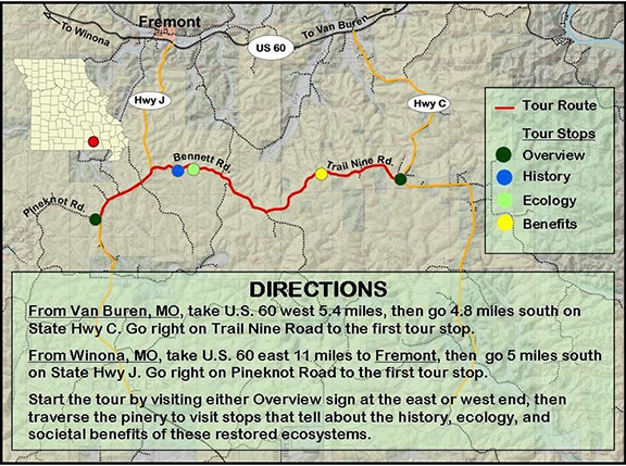
Interpretive signs along the tour explain the history, ecology, and societal benefits of these pine woodlands. Podcasts also accompany each tour stop, which visitors can access on their phones using a QR code posted on each interpretive sign.
Photos, maps, and podcasts for the Current River Pinery tour are available online at oakfirescience.com/current-river-pinery-self-guided-tour/
The tour traverses the Current River Pinery south of Fremont in Carter County. Visitors can witness expanses of shortleaf pine – once the dominant tree in this area – that are again maturing in woodlands with vigorous, wildlife-supporting undergrowth. Birds, butterflies, wildflowers, and small animals are all possible encounters at the tour stops.
The podcasts and signs describe the time before European settlement, when more than six million acres of fire-adapted shortleaf pine woodlands spread across the southern Missouri Ozarks; and they include information about the early 1900s timber boom which began a process that reduced pine woodlands to scattered fragments. They also demonstrate how some of the Ozarks’ best residual pine woodlands are in the Current River Pinery, where species remain that are declining elsewhere due to disappearing habitat.
DIRECTIONS: To tour the pinery, from Van Buren take U.S. 60 west 5.4 miles, then go 4.8 miles south on State Hwy C. Go right on Trail Nine Road to the first tour stop. Or, from Winona, take U.S. 60 east 11 miles to Fremont, then go 5 miles south on State Hwy J. Go right on Pineknot Road to the first tour these signs contain a map and directions to the other tour stops.

