
ST. LOUIS—The National Weather Service has released its preliminary report on the Coffman-St. Mary-Chester tornado.
Numerous severe thunderstorms formed ahead of an approaching cold front across southeast Missouri during the evening hours of Sunday, October 24th, 2021.
As the storms moved northeastward, they moved into a moist, energy-rich environment with substantial wind shear in the low and mid-levels.
They quickly grew intensified, remaining somewhat isolated as they moved through southeast Missouri and into southwest Illinois.
The environment was very favorable for tornadic development, and these storms produced several tornadoes and wind damage as they moved through the area.
Two storms produced tornadoes that remained on the ground for significant distances.
The tornado that moved through Fredericktown, Mo., passing through Madison County into Perry County, was on the ground for 18.9 miles.
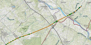
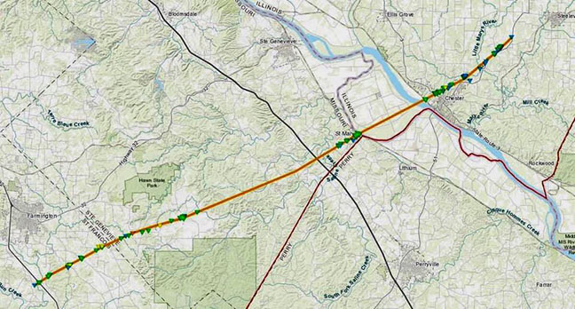
Another tornado moved from St. Francois County through Ste. Genevieve County in Missouri into Randolph County in Illinois, staying on the ground for over 40 miles.
![]()
Tornado: Coffman/St. Mary/Chester
St. Francois/Ste. Genevieve/Randolph Counties
Date October 24th, 2021
Time (Local) 8:23 – 9:28 PM CDT
EF Rating EF-3
Est. Peak Winds 150 mph
Path Length 42.4 miles
Max Width 450 yards
Injuries/Deaths 1/0
Summary:
The tornado began between Highway H and U.S. Highway 67 around 5.4 miles south-southeast of Farmington.
The tornado crossed U.S. Highway 67 where it topped, snapped, and uprooted trees.
The tornado traveled northeast paralleling a portion of Possum Hollow Road where tree damage was extensive with numerous snapped and uprooted trees.
Several homes along this stretch were damaged, primarily due to fallen trees.
The tornado then struck a farmstead near a bend in Possum Hollow Road where it completely destroyed two outbuildings. Neither of these structures were well-anchored and damage was rated at EF-1.
The tornado continued to the northeast snapping and uprooting trees.
A homeowner with 40 acres of land along Knob Lick Road estimated that 60-70 percent of the trees were destroyed.
Extensive damage was found near the intersection of Knob Lick Road and Old Fredericktown Road. Three homes in this area lost all or large portions of their roof with one home also losing portions of several walls. This damage was rated EF-2.
Damage from the homes, a destroyed garage, and trees was strewn hundreds of yards to the north. The path width of the tornado at this point was just over 400 yards.
The tornado then crossed Highway OO where the width was around 450 yards. A home lost part of its roof, a barn was damaged, and numerous trees were snapped or uprooted along this stretch. All of this damage was rated at EF-1.
The tornado crossed Smith Road destroying several barns and damaging a manufactured home, and then crossed Busiek Road damaging a small barn, several farm outbuildings and totally destroying a large well built farm outbuilding. Damage in this area was rated EF-1 or EF-2.
The 400+ yard wide tornado crossed the St. Francois County/Ste. Genevieve County line just north of Green Acres Lane. The tornado then traveled to the northeast crossing Route F multiple times as it traveled towards Coffman. Numerous trees were snapped or uprooted along this path, a number of farm outbuildings and barns were damaged or destroyed, and several homes suffered partial roof damage.
The worst damage occurred to a home on Route AA just north of Route F. This home was completely destroyed. All of the walls were completely blown into the rear of the foundation and the roof was totally removed. Little anchoring was evident to the walls.
One minor injury occurred to a male at the residence who found shelter in the pantry area; it was the only area that wasn’t completely crushed.
Tree damage in this area was some of the worst noted with every tree snapped or sheared supporting an EF-3 damage rating to the home.
Another home on McDaniel Road just north of Route F sustained severe damage. The roof was completely removed and a large portion of the northeast walls were removed. Little if any anchoring of the walls was evident.
The tree damage in this area as well as damage to surrounding structures was much less than that found along Route AA. Cumulatively these factors lead to an EF-2 damage rating of this home.
Numerous power poles and trees were snapped along Route F as the tornado traveled to the northeast into Coffman.
Crown Valley Brewing and Distilling suffered minor damage, however the building on the north side of Route F was heavily damaged, rated at EF-1.
A small building adjacent to the main Coffman Baptist Church was completely destroyed with debris blown into the main church building. There was no anchoring evident in this small building and damage was rated at EF-1.
The tornado continued to the northeast across eastern Ste. Genevieve County through heavily forested areas with limited access.
Scattered tree damage consisting of downed or snapped trees and branches was found.
The tornado then continued to the northeast into St. Mary.
Just to the southwest of St. Mary snapped trees were found and a farm outbuilding along St. Marys Church Road was completely destroyed.
Numerous trees were uprooted or snapped in St. Mary along with damage to 28 homes. The worst damage in St. Mary occurred along Church Street where one home lost its entire roof, and the roof was removed from a large portion of the St. Mary Antique Mall. This damage was rated EF-2.
The tornado continued to the northeast moving through flood plains and crossing the Mississippi River into Illinois just north of the Menard Correctional Center.
The tornado crossed Route 3 south of Lochhead Drive destroying a small barn, snapping or uprooting trees, and caused minor damage to several homes and a hardware store.
Snapped or uprooted trees and downed power poles were found along the remainder of the tornado track through Chester with roof damage to several homes on Brenda Street.
The worst damage in Chester occurred just northeast of the Palestine Road and Three Spring Roads intersection, where two farm outbuildings were completely destroyed. The larger of the two buildings was well-built with anchor bolts every 18-24 inches in the concrete foundation. This damage was rated EF-2.
Further northeast, minor roof damage and the loss of the roof-mounted HVAC unit was found at the nursing home near Old Lodge Lane and Three Springs Road.
The tornado continued to the northeast into Bremen paralleling and crossing Route 150, producing tree damage and minor roof damage to several homes.
Minor roof damage to several homes, damage to several farm outbuildings, and snapped and uprooted trees were found along parts of Chester Road and Paradise Road.
The worst of this damage was rated EF-1. The tornado dissipated around 1.6 miles northeast of Bremen, just west of Route 150.
*Note this preliminary damage survey will be updated in the coming weeks after analysis of high resolution satellite imagery. This dataset will allow for refinement of the starting/ending points and width along the track.